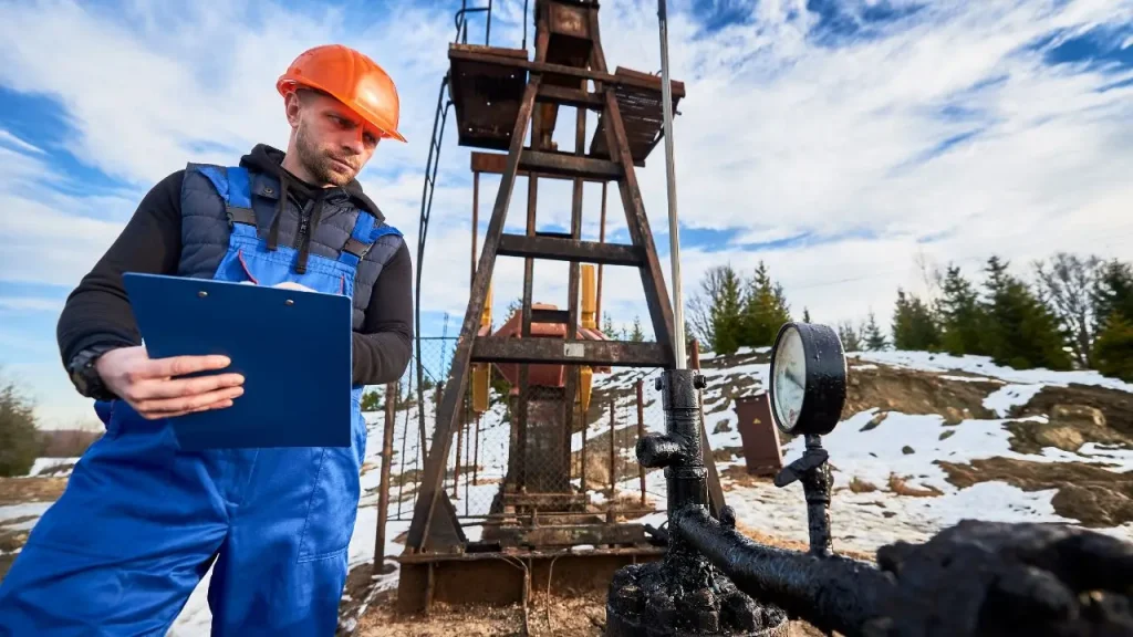
Geotechnical investigation is a critical first step in any construction project, laying the groundwork for safe and stable structures. It involves exploring subsurface conditions to understand soil and rock properties. Without this vital process, unforeseen ground issues can lead to costly delays, structural failures, and safety hazards.
This ultimate guide will delve into every aspect of geotechnical site investigation. We’ll explore the essential techniques, equipment, and analysis involved in gathering crucial data about the ground beneath your project. Understanding these foundations is key to successful and resilient construction.
What is Geotechnical Investigation?
A geotechnical investigation is a critical process in civil engineering and construction that involves assessing the physical properties of soil, rock, and groundwater at a proposed construction site. Its primary purpose is to determine the ground conditions’ suitability for the intended land use or structure.
This investigation provides essential data on soil strength, bearing capacity, stability, permeability, and the presence of any potential hazards like landslides, sinkholes, or expansive soils. The findings guide engineers in designing appropriate foundations, earthworks, and overall structural systems to ensure safety, durability, and cost-effectiveness of the construction project.
What is the Purpose of a Geotechnical Site Investigation
The primary purpose of a geotechnical site investigation is to systematically assess the subsurface conditions of a proposed construction site to gather essential information for safe, economical, and sustainable design and construction. This process helps engineers understand how the ground will interact with the planned structure, identify potential risks, and inform critical engineering decisions.
- Determine Soil and Rock Properties: To identify the type, strength, density, and other engineering characteristics of the ground materials present at various depths, crucial for foundation design.
- Assess Bearing Capacity: To evaluate the maximum load the soil can safely support without excessive settlement, informing the type and size of foundations required.
- Identify Geological Hazards: To detect potential issues like unstable slopes, liquefaction susceptibility, expansive soils, sinkholes, or fault lines that could impact the project’s stability.
- Locate Groundwater Levels: To determine the depth and fluctuations of the water table, which is critical for dewatering strategies, foundation design, and assessing potential buoyancy or groundwater contamination.
- Guide Foundation Design: To provide the necessary data for selecting the most appropriate and cost-effective foundation system (e.g., shallow footings, deep piles, rafts) for the anticipated loads and site conditions.
- Optimize Construction Methods: To inform decisions on excavation techniques, earthwork requirements, slope stability measures, and potential ground improvement needs, leading to more efficient construction.
- Ensure Regulatory Compliance: To provide documentation required by building codes and regulatory bodies, demonstrating that the project design is based on sound geotechnical principles and meets safety standards.
Why is Geotechnical Investigation Important?

Geotechnical investigation is a fundamental step in any construction project, providing crucial insights into subsurface conditions. Understanding the ground beneath a structure is paramount for safety, stability, and long-term performance.
Risk Mitigation
Geotechnical investigations are vital for identifying and mitigating potential geological hazards that could compromise a construction project. This includes detecting unstable soil layers, the presence of groundwater, seismic activity risks, or the potential for landslides and subsidence. By understanding these risks beforehand, engineers can implement appropriate design modifications, ground improvement techniques, or mitigation strategies, preventing costly failures, delays, and ensuring the safety of both the structure and its occupants.
Optimized Design and Cost-Effectiveness
Accurate geotechnical data enables engineers to design foundations and structural elements that are precisely tailored to the site’s specific ground conditions. This optimization avoids both over-conservative designs, which can lead to unnecessary material and construction costs, and under-designs, which can result in structural instability and future repairs. A well-informed design based on thorough investigation leads to efficient use of resources, reduced construction time, and significant long-term cost savings.
Regulatory Compliance and Safety
Conducting a comprehensive geotechnical investigation is often a mandatory requirement for obtaining building permits and ensuring compliance with local and national building codes. These investigations provide the necessary documentation to demonstrate that the proposed construction meets safety standards and environmental regulations. Ultimately, a thorough geotechnical assessment contributes directly to the overall safety of the construction process and the finished structure, protecting workers and the public.
Long-Term Performance and Durability
The insights gained from a geotechnical investigation are crucial for predicting how the ground will interact with the structure over its entire lifespan. Understanding factors like settlement characteristics, soil-structure interaction, and potential for erosion helps in designing for long-term durability and minimizing maintenance needs. This proactive approach ensures the structure remains stable and functional for decades, safeguarding its value and preventing premature deterioration.
Types of Geotechnical Investigation
Geotechnical investigations encompass various types, each tailored to specific project needs and site conditions. These approaches ensure comprehensive data collection for informed engineering decisions.
Preliminary Investigation
A preliminary investigation, also known as a desk study or reconnaissance, is the initial phase of assessing a site’s geotechnical suitability. This involves reviewing existing geological maps, historical aerial photographs, previous construction records, and local well logs to gather readily available information about the subsurface conditions.
Surface observations and a visual walkover of the site are also conducted to identify obvious features like drainage patterns, existing structures, and potential hazards. This phase helps in formulating a detailed scope for subsequent, more invasive investigations, identifying potential issues early and guiding the selection of appropriate drilling and testing methods.
Detailed Investigation
A detailed investigation is a comprehensive and in-depth assessment conducted after the preliminary phase, once a project is more defined. This type involves extensive fieldwork, including drilling numerous boreholes, excavating test pits, and performing a wide range of in-situ tests (e.g., SPT, CPT, DMT) to collect precise subsurface data.
Numerous soil and rock samples are retrieved for thorough laboratory analysis to determine detailed engineering properties. The aim is to gather all necessary information for the final design of foundations, earthworks, and other geotechnical structures, providing a robust understanding of complex ground behavior under proposed loads.
Supplementary Investigation
A supplementary investigation is conducted when additional geotechnical data is required during or after the main detailed investigation. This often occurs due to unforeseen ground conditions encountered during construction, changes in project design, or the need to address specific issues that were not fully resolved in earlier phases.
It might involve targeted drilling, specific in-situ tests, or specialized laboratory analyses focused on particular problematic areas or design modifications. This type of investigation is crucial for addressing emergent challenges, validating assumptions, and ensuring the continued safety and stability of the project.
Geotechnical Drilling and Investigation
Geotechnical drilling is the core process of obtaining subsurface information for site investigation. It involves advancing boreholes into the earth to extract samples and perform in-situ tests, providing direct data on soil and rock properties crucial for safe and efficient construction.
Rotary Drilling
Rotary drilling is a versatile and widely used method in geotechnical investigations, particularly for drilling through various soil and rock formations. This technique uses a rotating drill bit to cut and pulverize material at the bottom of a borehole.
Drill cuttings are then brought to the surface by circulating a drilling fluid (like water, air, or drilling mud) through the drill pipe and annulus. This method is effective for obtaining continuous core samples from rock and undisturbed samples from cohesive soils, making it suitable for deep explorations.
Auger Drilling
Auger drilling is a common and efficient method, especially for shallower geotechnical investigations in cohesive soils and soft rock formations. It involves rotating a helical screw-like auger into the ground, which then brings the excavated material to the surface.
Both solid stem augers (for continuous sampling) and hollow stem augers (which allow for sampling and in-situ testing through the hollow core without removing the auger string) are utilized. This method is relatively fast and cost-effective, but less effective in unconsolidated or flowing sands.
Percussion Drilling
Percussion drilling, also known as cable tool drilling, involves repeatedly lifting and dropping a heavy cutting tool (a drill bit) into the borehole. The impact breaks up the soil or rock, and the loosened material is then removed using a bailer.
This drilling method is particularly effective for drilling through hard rock, gravel, and boulders where other methods might struggle. While slower than rotary drilling, it can produce very accurate samples and is often used for groundwater monitoring well installations.
Direct Push (DP) or Geoprobe Drilling
Direct Push (DP) or Geoprobe drilling involves hydraulically pushing small-diameter tools and sensors directly into the ground without rotation or removal of cuttings. This method is very efficient for rapid subsurface profiling, environmental investigations, and obtaining soil and groundwater samples at shallow to moderate depths in unconsolidated soils. It minimizes soil disturbance and generates minimal waste, making it a “cleaner” alternative for many site assessments.
Core Drilling
Core drilling is a specific type of rotary drilling designed to extract intact cylindrical samples (cores) of rock or very hard soil. It uses a diamond-impregnated or carbide-tipped core barrel that cuts an annular ring into the formation, leaving a solid core inside. This method provides the highest quality samples for detailed laboratory analysis of rock properties, including strength, discontinuity, and permeability, crucial for foundation design in bedrock.
Drilling Rig for Geotechnical Investigation
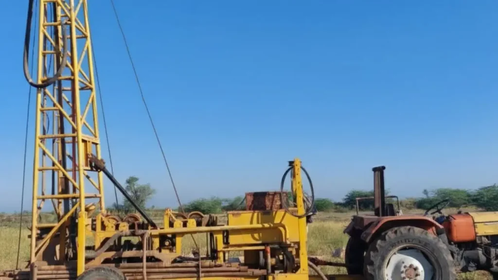
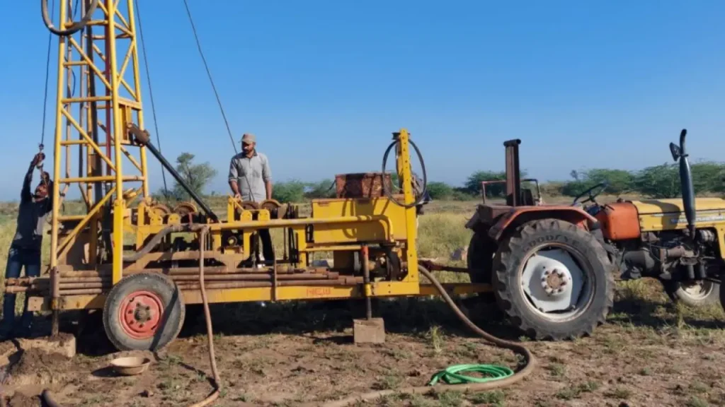
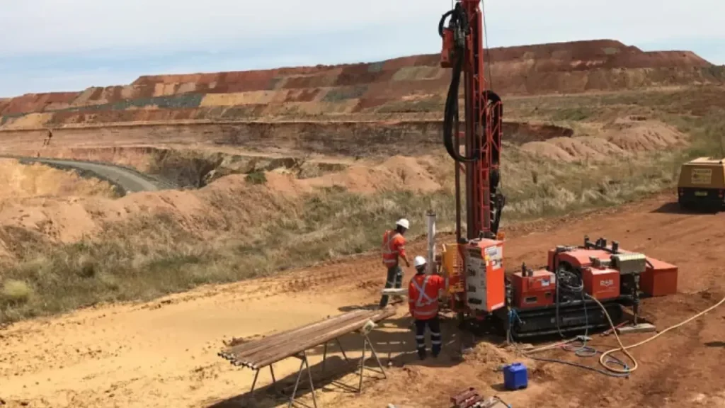
Drilling rigs are the workhorses of geotechnical investigation, enabling access to subsurface materials for sampling and in-situ testing. Their selection is critical, depending on site conditions, required drilling depth, and the type of geological formations encountered.
Truck-Mounted Drill Rigs
Truck-mounted drill rigs are highly versatile and widely used for geotechnical investigations due to their mobility and power. These rigs are mounted directly onto a truck chassis, allowing for rapid deployment to various sites, including those with relatively good road access. They are capable of performing a wide range of drilling techniques, such as auger drilling, rotary drilling, and coring, making them suitable for diverse soil and rock conditions. Their self-contained nature and ability to carry necessary tools and water contribute to efficient fieldwork.
Track-Mounted Drill Rigs
Track-mounted drill rigs, also known as crawler rigs, are designed for superior maneuverability and stability on challenging terrains. Equipped with rubber or steel tracks, these rigs can access remote, uneven, or soft ground conditions that wheeled vehicles cannot. Their low ground pressure minimizes disturbance to sensitive sites, while their robust construction allows for deep drilling and handling difficult geological formations. They are commonly used in mountainous regions, wetlands, or sites with limited access.
All-Terrain Vehicle (ATV) Mounted Drill Rigs
ATV-mounted drill rigs are compact and lightweight, specifically designed for highly restricted or environmentally sensitive access areas. These rigs can be transported by helicopter or disassembled for manual portaging, making them ideal for remote wilderness sites, dense forests, or steep slopes. Despite their smaller size, they are capable of various drilling methods, including auger and core drilling, providing essential subsurface information where larger rigs are impractical.
Man-Portable Drill Rigs
Man-portable drill rigs are the most compact and lightweight option, designed to be disassembled into small components that can be carried by hand. This makes them indispensable for investigations in extremely remote, inaccessible locations, or environmentally protected areas where even ATVs cannot operate. While their drilling depth and power are limited compared to larger rigs, they are crucial for obtaining critical samples and performing shallow in-situ tests in challenging terrains.
Heli-Portable Drill Rigs
Heli-portable drill rigs are specialized rigs designed for transportation by helicopter, enabling access to the most remote and challenging sites where no other ground-based access is possible. These rigs are modular, breaking down into components that fit helicopter cargo slings. They offer significant drilling capabilities, including deep coring in rock, making them essential for large-scale infrastructure projects in mountainous or undeveloped regions where traditional access is impossible.
Steps on How to Do a Geotechnical Investigation
A geotechnical investigation follows a systematic process to thoroughly assess subsurface conditions, ensuring comprehensive data collection and analysis for sound engineering decisions.
Each step builds upon the last, leading to a robust understanding of the site. Here are the steps about the geotechnical investigation procedure:
Step 1: Planning and Scoping
Effective geotechnical investigations begin with meticulous planning and scoping. This initial phase involves clearly defining the objectives of the investigation, which are tailored to the specific project requirements, such as foundation design, slope stability analysis, or groundwater control. Engineers meticulously determine the necessary extent of testing, considering factors like the site’s size, its complexity, the proposed structural loads and tolerances, and any relevant regulatory or environmental constraints.
Furthermore, this stage includes crucial logistical considerations. Planning addresses site access challenges, particularly for remote or restricted locations that might necessitate specialized, portable drilling equipment. Safety protocols are also prioritized, involving assessments for potential hazards like proximity to existing utilities or the presence of hazardous materials, ensuring the well-being of the investigation team.
Step 2: Site Assessment
The second step involves an initial site reconnaissance, a critical preliminary evaluation to identify key geological and environmental factors. Geologists and engineers conduct thorough surface inspections, observing features such as visible soil outcrops, existing drainage patterns, and vegetation types, which can provide valuable clues about the subsurface conditions. These preliminary observations often hint at the presence of specific soil characteristics, such as weak or expansive soils, before any invasive testing begins.
During this phase, potential geological hazards are also identified early in the process. This includes assessing risks from seismic activity by mapping fault lines and liquefaction zones, testing for soil contamination that could impact construction or require remediation, and evaluating the risk of landslides in hilly or mountainous terrain. Field surveys at this stage are often augmented by reviewing historical data, analyzing aerial imagery, and utilizing geospatial mapping for a holistic understanding of the site’s history and current state.
Step 3: Field Work
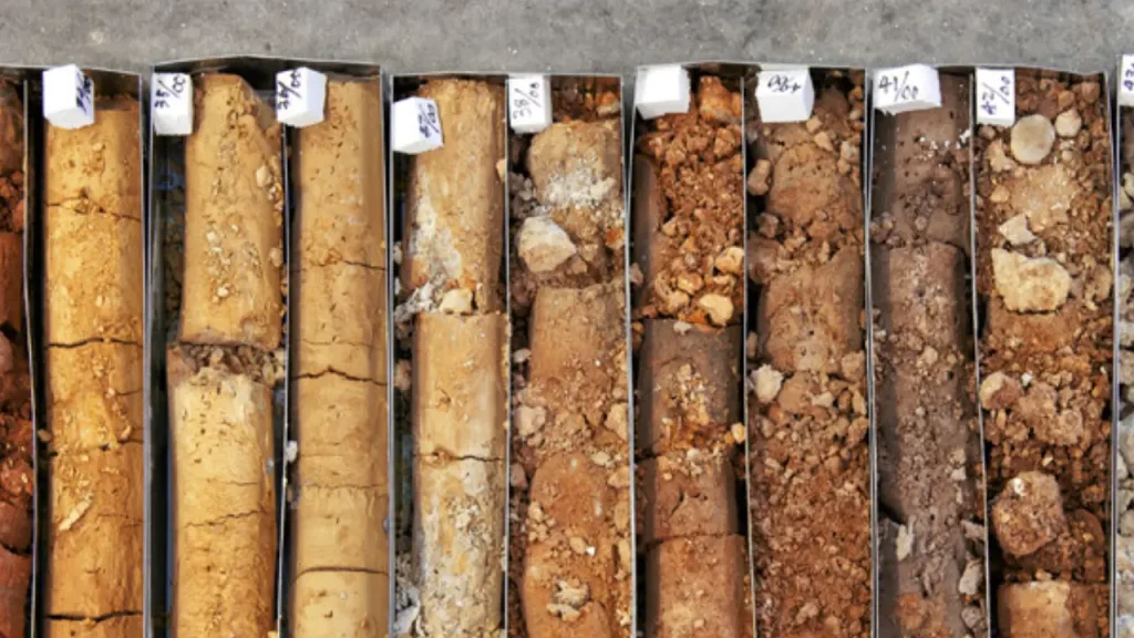
Fieldwork forms the backbone of geotechnical investigations, involving various techniques to collect direct subsurface data. This primarily includes drilling boreholes at strategic locations and depths, which are determined by the site’s size and specific project requirements. From these boreholes, soil and rock samples are meticulously extracted at different depths, providing physical specimens for detailed laboratory analysis.
In-situ testing is also performed on-site to gather real-time data on soil behavior under actual conditions. Common methods include the Standard Penetration Test (SPT), which measures soil resistance to penetration, offering insights into density and bearing capacity. The Cone Penetration Test (CPT) assesses soil strength and stratigraphy by measuring resistance during cone penetration. Other tests like Pressuremeter and Vane Shear Tests evaluate stress-strain relationships and shear strength. Adherence to standards like ASTM D1586 (SPT) and ISO 22476 (CPT) ensures the reliability of these field data.
Step 4: Laboratory Testing
After fieldwork, the collected soil and rock samples undergo rigorous laboratory analysis to determine their detailed engineering properties. This phase is crucial for understanding how the materials will behave under the stresses of the proposed construction. Common tests include Atterberg Limits, which define soil plasticity and help classify its type (e.g., clay, silt, sand).
Shear strength tests are conducted to assess the soil’s resistance to shearing forces, a critical parameter for foundation design and slope stability. Permeability tests measure the rate at which water flows through soils, providing essential data for drainage design and dewatering strategies. Consolidation tests are performed to estimate the potential settlement of soils under sustained loads. The comprehensive results from these laboratory analyses are fundamental for developing accurate geotechnical models and predictions.
Step 5: Data Analysis and Interpretation
Synthesizing all collected field and laboratory data is a critical step in developing a coherent and comprehensive understanding of the site’s geotechnical conditions. Engineers employ specialized software to model subsurface behavior, allowing them to predict how the ground will perform under varying load conditions imposed by the proposed structure. During this phase, key geotechnical parameters such as bearing capacity, expected settlement, and slope stability are meticulously evaluated.
This stage involves a thorough integration of all available information. Field observations, the results from in-situ tests, detailed laboratory analyses, and relevant historical records are combined to generate comprehensive site profiles. This integrated approach allows for the development of accurate risk assessments, identifying potential hazards and informing the subsequent design recommendations to mitigate these risks effectively.
Step 6: Reporting and Recommendations
The geotechnical investigation culminates in a detailed geotechnical report, which serves as the foundational document for all subsequent design and construction decisions. This comprehensive report systematically presents all findings from the investigation. It includes summarized data on soil and rock properties at different depths, detailed groundwater levels, and a thorough description of overall site conditions.
Crucially, the report provides actionable recommendations for the project. This guidance includes specific advice on foundation design (e.g., shallow, deep, raft), necessary slope stabilization measures, and essential drainage requirements. It also incorporates comprehensive risk assessments, identifying any potential geological hazards and outlining concrete mitigation strategies.
To ensure credibility and acceptance by stakeholders and regulatory bodies, the report must strictly adhere to relevant regional and international standards, such as Eurocode 7 or ASTM guidelines.
Drilling Tools for Geotechnical Investigation

Geotechnical drilling relies on a variety of specialized tools to effectively penetrate different ground conditions, retrieve samples, and perform in-situ tests. The selection of these tools is crucial for obtaining accurate data and ensuring the efficiency of the investigation.
Drill Bits
Recommended Drill Bits for Geotechnical Investigation


Drill bits are at the forefront of the drilling process, designed to cut or pulverize soil and rock formations. Their type varies significantly based on the material being drilled. For soft soils, fishtail or drag bits are common. For harder formations, roller cone bits with rotating cones or diamond-impregnated bits for coring hard rock are used. The choice of drill bit directly impacts drilling speed, sample quality, and the ability to penetrate challenging geological layers efficiently.
Augers
Augers are helical-shaped tools used primarily for drilling in soft to medium-stiff cohesive soils, sands, and some weathered rock. Solid stem augers bring cuttings to the surface along their flights, providing disturbed samples. Hollow stem augers, on the other hand, allow for continuous sampling or in-situ testing through their hollow core without the need to remove the entire auger string, making them highly efficient for environmental and shallow geotechnical investigations.
Core Barrels
Core barrels are specialized tools used in rotary drilling to obtain intact cylindrical samples (cores) of rock or very stiff soil. They consist of a barrel with a cutting bit at the bottom, typically impregnated with diamonds. As the core barrel rotates, it cuts an annular ring, allowing the core to pass into the barrel. Various types exist, such as single tube, double tube, and triple tube core barrels, chosen based on the desired sample quality and the friability of the material being cored.
Samplers
Samplers are critical tools for retrieving soil and rock samples from boreholes for laboratory analysis. Common types include split-spoon samplers (used with SPT for disturbed samples), Shelby tube samplers (for obtaining undisturbed samples of cohesive soils), and piston samplers (for high-quality undisturbed samples, particularly in soft clays). The choice of sampler depends on the soil type, depth, and the specific laboratory tests to be performed, as sample disturbance must be minimized.
In-Situ Testing Tools
A range of specialized tools is used for performing in-situ tests directly within the borehole or by pushing into the ground. These include the cone penetrometer (for CPT and CPTu tests), vane shear test apparatus (for measuring undrained shear strength of clays), and pressuremeter (for determining stress-strain properties). These tools provide real-time data on soil properties under actual ground conditions, complementing laboratory analysis of retrieved samples and offering immediate insights into subsurface behavior.
Advanced Techniques in Geotechnical Investigation

Beyond conventional methods, advanced geotechnical investigation techniques provide more detailed and nuanced data, crucial for complex projects or challenging ground conditions. These cutting-edge approaches enhance accuracy, reduce invasiveness, and offer real-time insights into subsurface behavior, leading to more robust and optimized designs.
- Geophysical Methods: These non-invasive techniques (e.g., seismic refraction, electrical resistivity, ground-penetrating radar) use physical principles to image subsurface structures. They help identify soil stratigraphy, locate bedrock, detect groundwater, and map buried utilities without extensive drilling, offering broad site coverage efficiently.
- Piezocone Penetration Test (CPTu): An evolution of CPT, the CPTu simultaneously measures tip resistance, sleeve friction, and pore water pressure. This provides highly detailed, continuous data on soil type, strength, density, and drainage characteristics, crucial for assessing liquefaction potential and settlement.
- Dilatometer Test (DMT): The DMT is an in-situ test that measures soil stiffness and strength parameters by expanding a membrane into the soil. It provides reliable estimates of stress history, overconsolidation ratio, and settlement characteristics, particularly useful for soft clays and silts.
- Downhole Seismic Testing: This method involves generating seismic waves at the surface and measuring their travel time to receivers in a borehole. It accurately determines shear wave velocities and dynamic soil properties, which are essential for seismic design and liquefaction analysis of structures.
- Remote Sensing and UAV (Drone) Surveys: Utilizing drones and satellite imagery allows for large-scale topographical mapping, precise photogrammetry, and multispectral analysis. These techniques provide detailed elevation models, monitor ground deformation, and identify geological features over vast or inaccessible areas efficiently.
- Laboratory Advanced Soil Testing: Beyond standard tests, advanced lab methods (e.g., triaxial compression, resonant column) determine complex soil behavior. These provide stress-strain relationships, liquefaction resistance, and dynamic properties under simulated field conditions, vital for critical infrastructure design.
Geotechnical Investigation Cost
The cost of a geotechnical investigation can vary significantly, influenced by numerous factors that dictate the scope, complexity, and duration of the work. While it represents an initial investment, a thorough investigation typically leads to long-term savings by preventing costly design errors, construction delays, and unforeseen problems.
- Project Scale and Complexity: Larger projects with heavier loads, complex structures, or challenging geological conditions (e.g., steep slopes, deep foundations, seismic zones) require more extensive and intricate investigations, driving up costs.
- Site Accessibility: Remote, difficult-to-access, or hazardous sites increase logistical costs due to specialized equipment, longer travel times, and additional safety measures required for personnel and machinery.
- Required Depth and Number of Borings: Deeper investigations and a greater number of boreholes or test pits increase drilling time, labor, and equipment usage, directly impacting the overall cost.
- Type and Number of Tests: The specific in-situ tests (e.g., SPT, CPT, DMT) and laboratory analyses (e.g., Atterberg limits, shear strength, consolidation) performed will significantly influence the cost, as some tests are more labor-intensive or require specialized equipment.
- Geological Conditions: Sites with highly variable or challenging ground conditions, such as karstic terrain, boulders, contaminated soil, or high groundwater levels, may require more advanced drilling techniques, additional testing, and longer investigation periods, leading to higher costs.
- Reporting Requirements and Expertise: The level of detail required in the geotechnical report, including advanced modeling or specialized recommendations, can affect the cost, as can the seniority and expertise of the geotechnical engineers involved.
Conclusion
A geotechnical investigation is crucial for understanding subsurface conditions, mitigating risks, and ensuring safe, stable construction. This guide highlights its importance in revealing soil properties, groundwater levels, and potential hazards, all vital for informed engineering decisions and project success.
Thorough site investigation minimizes unforeseen challenges, leading to optimized designs and preventing costly structural failures. It’s an investment that safeguards both project integrity and long-term performance, laying the foundation for reliable infrastructure development.
For all your geotechnical drilling needs, get wholesale geotechnical drilling tools from Sinodrills.